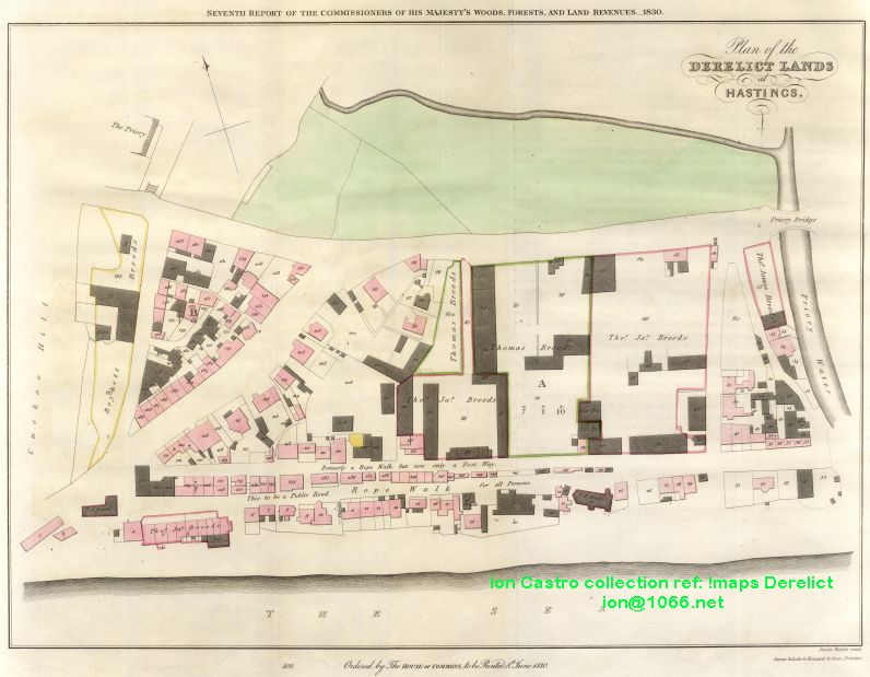
| In central Hastings is an area covered by Harold Place, the Queens Hotel, Robertson Terrace, Carlisle Parade, White Rock, Robertson Street, Trinity Street, and Claremont, this area to the West of the Priory-Stream was outside the Hastings Borough boundary and was the result of the sea receding. This land was settled by squatters who named it "The America Ground" and declared themselves independent of Hastings. They built houses shops and warehouses and paid no rent rates or taxes. The borough suggested that lawlessness was rife and the government should take steps to get rid of the nuisance. | ||
|
||
The America Ground,
|
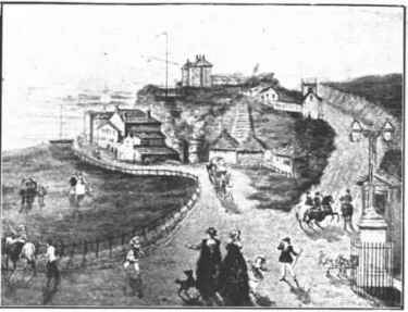
 The White Rock, showing the road round it and the " America Ground" covered with buildings, about 1824, before being cleared by the government. |
|
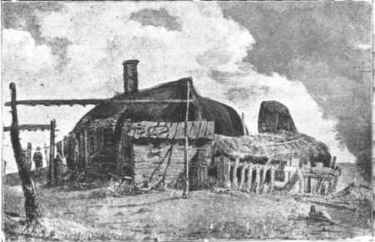
The rope walk (now the site of Robertson Street) early 19th-century |
To the present day observer, large areas of flat ground do not seem to be lacking on the seafront at Hastings but times have changed. Where formerly the sea pounded great cliffs and scoured the beaches now promenades abound. Every inch of ground was at a premium. Look at the old houses clinging to the cliffs for proof of this. It was logical therefore that a ropewalk was developed on the new shingle bank, it was probably the flattest, straightest piece of ground for miles. The practical logic of working folk would demand that nothing was wasted so derelict boat hulls were pressed in to service to provide cover against the weather. The effect and requirements of rope-working would both need and produce a long straight hardened surface, in modern times we forget the luxury of a hard, well-drained area on which to move around. That this became the main thoroughfare of the future America Ground should be no surprise to us. The ropewalk became something of attraction to the rich and idle, as always, the industry and ingenuity of the poor and needy when fighting poverty and starvation was considered "quaint". And many drawings and prints were produced of this extraordinary construction.
|
|
A certain legitimacy for the presence of the ropemakers was gained by the payment of small rents to Hastings Corporation (possessors of a powerful Elizabethan Charter) and the Earl of Chichester who held the Castle lands. Ropemaking on the shingle bank had virtually ceased by the 1820s due mainly to the advent of the Industrial Revolution and the coming of factory-made cordage, whether home produced or imported. But by now a new industry was emerging. Quaint Hastings, facing South and in easy reach of London, was the ideal resort for the affluent middle classes, where they could both enjoy the views and cast a superior and critical eye over the fascinating, hardworking fishing port to the east in Hastings Old Town, then reaching its peak, providing the South East of England with its breakfast kippers. At this time as I have indicated before, land was very much at premium and the near derelict Ropewalk provided perfect lodgings for the growing numbers of workers (and those providing for their needs and requirements) employed on the various construction projects in hand. The removal of the West Hill cliff and the subsequent building of Pelham Crescent (1820s) in its place foremost among them. By 1822 it was estimated that more than 1000 souls had acquired ramshackle, incommodious but rate-free accommodation on the shingle bank, guaranteed to provoke the great and the good on the Borough Council, Aldermen and councillors alike. Added to the freedom from expense there was the allegation (equally provoking but largely unfounded) of lawless and licentious behaviour amongst the inhabitants of this motley collection of habitations. A few half-hearted attempts were made to impose official control and the immediate response to this was the American flag (a contemporary symbol of freedom) being run up in defiance. And so the America Ground was born. This is well underlined if time is taken
to study the survey carried out *after* the Crown Commissioner's Inquisition mentioned below. And
reported in the Seventh Report of
His Majesty's Commissioners, dated 8th June 1830, published and printed on the order of the House of Commons.
The survey, which appears as
Appendix 15 & 16 of the report, makes interesting reading. It shows that contrary to popular
understanding that
there was a dispute over the ownership of the land. On the one hand, Lord Chichester as holder to the Castle lands
laid claim to it under
a grant made to his family under James the 1st. And on the other Hastings Corporation claimed it
under their Charter from Elizabeth the 1st. |
The America Ground was not the haphazard collection of squats that officialdom liked to imply. It was
a properly organized community supplying most if not all of its own needs. Barry Funnel's "The
America Ground"
tells us that it had among others a "carpenter, miller, mast and blockmaker, baker, brewer,
cowkeeper, fishermen, gardener". Lodging houses were a major industry as was pigkeeping, in fact these two
appear to be the main
sources of activity, dominating all others. These others
The "America Ground" from the coastguard station, Cuckoo Hill. The large open space, after being cleared of the houses shown in in the plan, by government and covered by Carlisle Parade, Queens Hotel, Robertson Terrace, Robertson Street, Trinity Street, and Claremont. View published by George Curling Hope, 1850 |
|
Worth noting are the final smug comments of the Commissioners. Where after praising themselves on the
generosity in the granting of seven year leases, they observe:
|
||
So what did the surveyors, Messrs Driver
of Battle find? The Brig "Polymina" converted into a cottage in 1806 and gardener, James
Howell's, mobile home. Of the rest
of the accommodation listed, the majority appears to have been brick and stone. Timber buildings
certainly existed but appeared to
be generally for workshops and animal containment. 199 premises (some of them given the same number several
times) and 99 prospective lessees
are named. One can only speculate as to why the number of properties were kept below 200 and the lessees
below 100. The reader can draw their own conclusions as the nature of the community these people created. Though I do observe that there is neither solicitor nor minister of the church listed in the survey. |
The reality was somewhat different, if less romantic. The prospective lessees were as follows: |
|
Merchants 3. |
Publican 1. Butchers 3. Shipowner 1. Bricklayers 2. Cornfactor 1. Tax Collector 1. Cabinet Makers 2. Shoemaker 3. Wheelwright 1. Coachman 1. Mariners 3. Ropemaker 1. Ostler 1. Grocers 2. Stabler 1. Gardener 1. |
|
 Site of Robertson Street, Hastings, in 1846. The Lime Kilns, Claremont, watercolour by Charles Turner RA. The open space is the "America Ground" Cambridge Road on the right, with the road round the White Rock coastguards station on St.Michael's Rock |
The first signs of trouble began when it
was found that no title deeds existed to enable the sale of property on the America Ground and the
matter was referred to the Crown
Authorities. And in turn the query was passed on to the Commissioners for Woods, Forests and Land Revenues. An inquisition was called for, and another claimant duly appeared on the scene, Lord Cornwallis, holder of the Priory Estate. Now there were three, Lord Cornwallis, The Earl of Chichester and Hastings Corporation. Later, Battle Abbey Estates (Sir Godfrey Webster) would be invited to make a claim. On the 6th of December 1827, five commissioners and twelve jurymen met at the George Hotel at Battle and quickly decided that the lands should be seized on behalf of the King. There is no record on documents of the residents of the America Ground being consulted or even referred to. |
|
Apart from the map the pictures
of this article are from "Hastings of bygone days -- and the present" by Henry Cousins, (c) 1999 Brian Fraser Lovett-White www.finhall.co.uk |
||
![]()
![]()
![]()
![]()
![]()
020825
080530
090717
110615
121205
150526
161017